This set of Surveying Multiple Choice Questions & Answers (MCQs) focuses on “Errors in GIS”.
1. Which of the following doesn’t indicate a topology error?
a) Polygonal features
b) Gaps between polygons
c) Silver polygons
d) Unclosed polygons
View Answer
Explanation: Topology errors generally include polygonal features, gaps between polygons, overlapping polygon borders and unclosed polygons. Some of these are negligible and some of them can be reduced by following certain precautions and by applying some parameters.
2. Which of the following acts as a source of inaccuracy?
a) Format of data
b) Silver polygon
c) Unclosed polygon
d) Dongle nodes
View Answer
Explanation: Difference in scale, age of data, format of the data, qualitative and quantitative errors act as a source of inaccuracy. Inaccuracy develops due to lack of technique in the work which is being done.
3. Among the errors occurring in GIS, which can cause a drastic change or fail the entire process?
a) Format of data
b) Unclosed polygons
c) Dongle nodes
d) Silver polygons
View Answer
Explanation: Development of silver polygons leads to the creation of similar polygonal features, which arises a lot of confusion to the user as well as the software. It can’t differentiate them and in turn merges them to make a single feature.
4. Which of the following is not a category of error?
a) Change in format
b) Areal cover
c) Map scale
d) Density of observation
View Answer
Explanation: Sources of errors include aging of data, areal cover, map scale, density of observation, etc., these are temporary and can be adjusted by following certain parameters. These can be prevented if proper care is taken while the procedure is carried out.
5. Age of data can act as a source of error.
a) False
b) True
View Answer
Explanation: Aging of data acts as a major source of error. Past data may contain a lot of unknown standards which can’t be used in the present day. They might be irrelevant to the present situation and sometimes they won’t exist.
6. Which of the following can be represented as an example of format error?
a) Silver polygons
b) Dongle nodes
c) Changing from raster to vector
d) Areal cover
View Answer
Explanation: After completion of interpretation using GIS software, the data must be stored in any type of software which can be easily accessible. If the stored data undergone any change in format, it may or may not be able to open. If it doesn’t open, then the entire data present in it can be erased.
7. Silver polygons occur due to excessive overlaying.
a) False
b) True
View Answer
Explanation: GIS process involves overlaying procedure in which the data can be placed layer by layer without any confusion. While placing, there is a chance of developing silver polygons which means the development of polygons one on another. It leads to merging of data and ends up creating a single polygon rather than many.
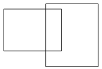
8. The figure represents which type of error in GIS?
a) Pseudo node
b) Silver polygon
c) Dongle node
d) Poly line feature
View Answer
Explanation: The figure represents the silver polygon, which is a condition where the overlapping polygon takes place in the GIS software. This can be removed by deleting unnecessary data.
9. The figure given below represents which topological error?

a) Pseudo nodes
b) Silver polygon
c) Dongle nodes
d) Polygonal feature
View Answer
Explanation: The figure represents pseudo nodes, which is a condition where nodes of the poly lines aren’t connected. In order to connect them, vertex must be corrected for having a better result.
10. Dongle nodes can be removed by ___________
a) Undo
b) Eraser
c) Behind shoot
d) Over shoot
View Answer
Explanation: Dongle node is a condition where the edge of the polygon is improperly connected to the second poly line. The removal of dongle nodes can be done by applying undershoot or over shoot operations.
Sanfoundry Global Education & Learning Series – Surveying.
To practice all areas of Surveying, here is complete set of 1000+ Multiple Choice Questions and Answers.
If you find a mistake in question / option / answer, kindly take a screenshot and email to [email protected]
- Apply for Civil Engineering Internship
- Check Civil Engineering Books
- Practice Civil Engineering MCQs
- Check Surveying Books
