This set of Surveying Multiple Choice Questions & Answers (MCQs) focuses on “Theodolite – Traverse Area Calculation”.
1. Which of the following doesn’t involve the method of traversing?
a) Chain surveying
b) Theodolite surveying
c) Plane Table surveying
d) Tacheometric surveying
View Answer
Explanation: Depending on the instruments used in determining the relative directions of the traverse lines. The principal methods adopted are Chain traversing, Compass traversing, Transit tape traversing, Plane-table traversing. Tacheometric surveying involves a lot of instrumental work rather than ground work.
2. Which among the following is a procedure for computation of traverse area?
a) Calculation and adjustment of latitudes and departures
b) Adjustment of instrument
c) Calculation of consecutive co-ordinates
d) Determination of R.L
View Answer
Explanation: The procedure for traverse calculations involves Adjusting angles or directions, determining bearings or azimuths, calculation and adjustment of latitudes and departures, calculation of rectangular coordinates.
3. Adjustments applied to angles are independent of the size of the angle.
a) False
b) True
View Answer
Explanation: The adjustments applied to angles are independent of the size of the angle because they depend on the direction in which they are present.
4. Which of the following is the first step for determining the azimuth or bearing?
a) Determination of angles or bearings
b) To determine the true direction
c) The direction of at least one line within the traverse must be known or assumed
d) Determining the latitudes and departures
View Answer
Explanation: The direction of at least one line within the traverse must be known or assumed because it would be easy for calculating the bearings by taking reference from that assumed direction.
5. For calculating the traverse area, which of the following is crucial?
a) L = 0, D = 0
b) ∑L2 = 0, ∑D2 = 0
c) ∑L ≠ 0, ∑D ≠ 0
d) ∑L = 0, ∑D = 0
View Answer
Explanation: In order to nullify the closing error, the algebraic sum of latitudes and the algebraic sum of departures must be equal to zero, which is necessary for obtaining the total traverse area.
6. For adjusting the traverse, which of the following methods can be used?
a) Compass traversing
b) Chain traversing
c) Theodolite traversing
d) Bowditch’s method
View Answer
Explanation: Adjusting is generally applied to the operation of applying corrections to latitudes and departures so that ∑L = 0, ∑D = 0. This applies only when the survey forms a closed polygon. The common methods of adjusting a traverse include Bowditch’s method, Transit method, Graphical method and Axis method.
7. Angle and distance is one of the methods for plotting a traverse survey.
a) True
b) False
View Answer
Explanation: The two principal methods of plotting a traverse survey are angle and distance method, Co-ordinate method. In this method, distances between stations are laid off to scale and angles are plotted by protractor, by tangent rule or by chords.
8. Which of the following is the accurate method for plotting traverse area?
a) Transit method
b) Angle and distance method
c) Co-ordinate method
d) Bowditch’s method
View Answer
Explanation: In Co-ordinate method, survey stations are plotted by calculating their co-ordinates. It is the most practical and accurate one for plotting traverses or any other extensive system of horizontal control. The advantage in this method of plotting is that the closing error can be eliminated by balancing.
9. Which of the following methods will give the accurate result while traversing?
a) Loose needle method
b) Fast needle method
c) Chain traversing
d) Compass traversing
View Answer
Explanation: In fast needle method, the magnetic bearings of traverse lines are measured by a theodolite. The magnetic bearings of the lines are measured with reference so the direction of magnetic meridian is established at the first station. This method is, therefore, more accurate than the loose needle method. Fast needle method includes direct method with transiting, direct method without transiting, back bearing method.
10. Among the following, which indicates the formula for balancing angles of closed traverse?
a) ∑ Interior angles = (n+2) * 1800
b) ∑ Interior angles = (n-2) / 1800
c) ∑ Exterior angles = (n-2) * 1800
d) ∑ Interior angles = (n-2) * 1800
View Answer
Explanation: The formula for balancing the angles of closed traverse
∑ Interior angles = (n-2) * 1800
Where, n = number of interior angles.
By using this, the error in the interior angles can be checked and can be minimised.
11. Calculate the area of traverse for the figure, if lengths of AB, BC, CD, and DA are 12.98 m, 98.23 m, 19.77 m, 34.67 m and the angles α, β given as ____________
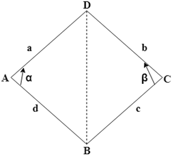
a) 1086.55sq. m
b) 698.41sq. m
c) 1068.91 sq. m
d) 689.14 sq. m
View Answer
Explanation: The figure can be divided into two triangles, which forms, ABD and BCD.
Area of triangle ABD = (1 / 2) * (ad)* sin α = (1 / 2) * (12.98*34.67) * sin () = 194.07 sq. m
Area of triangle BCD = (1 / 2) * (bc) * sin β = (1 / 2) * (98.23*19.77) * sin () = 892.48 sq. m
The total are can be given as 194.07 + 892.48 = 1086.55 sq. m.
12. What will be the value of DMD for B if DMD for A is -22.87, departures for A & B will be -22.87, +89.24 respectively?
a) 22.8
b) 43.5
c) -43.5
d) -22.8
View Answer
Explanation: DMD (Departure Median Distance) for the station B can be given as
DMD of A + Departure of A + Departure of B
= -22.87 – 22.87 + 89.24 = +43.5.
13. Calculate the value of double area if the value of latitude of A is 235.67 m and DMD is +89.26 m.
a) 20135 sq. m
b) 21305 sq. m
c) 21035 sq. m
d) 20035 sq. m
View Answer
Explanation: The value of double area can be calculated as the product of latitude and DMD. It can be given as
Latitude * DMD = 235.67 * 89.26 = 21035 sq. m.
Sanfoundry Global Education & Learning Series – Surveying.
To practice all areas of Surveying, here is complete set of 1000+ Multiple Choice Questions and Answers.
If you find a mistake in question / option / answer, kindly take a screenshot and email to [email protected]
- Practice Civil Engineering MCQs
- Check Surveying Books
- Apply for Civil Engineering Internship
- Check Civil Engineering Books
