This set of Tricky Surveying Questions and Answers focuses on “Introduction – Conventional Symbols”.
1. Identity the below symbol.

a) Well
b) Dam
c) Boundary pillar
d) Statue
View Answer
Explanation: Generally, wells are circular in shape. Hence, ISO standard symbol for well in Topographic surveying is solid circle.
2. Identity the following symbol.
![]()
![]()
a) Well
b) Dam
c) Boundary pillar
d) Statue
View Answer
Explanation: Generally, boundary pillars are square in shape. Hence, ISO standard symbol for boundary pillars in Topographic surveying is solid square.
3. Identity the following symbol.
![]()
![]()
a) Well
b) Earthwork dam
c) Boundary pillar
d) Statue
View Answer
Explanation: The above symbol is standard conventional sign for earthwork dam. This symbol is used to represent the earthwork dam in topographic map.
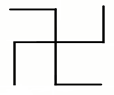
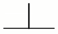
4. Identity the following symbol.

a) Well
b) Earthwork dam
c) Boundary pillar
d) Statue
View Answer
Explanation: The above symbol is standard conventional sign for statue. This symbol is used to represent the statue in topographic map.
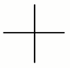
5. Identity the following symbol.
a) Temple
b) Church
c) Police station
d) Statue
View Answer
Explanation: The above symbol is standard conventional sign for temple. This symbol is used to represent the temple in topographic map.
6. Identity the following symbol.
a) Temple
b) Church
c) Police station
d) Statue
View Answer
Explanation: The above symbol is standard conventional sign for police station. This symbol is used to represent the police station in topographic map.
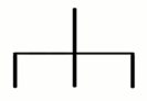
7. Identity the following symbol.
a) Temple
b) Church
c) Police station
d) Statue
View Answer
Explanation: The above symbol is standard conventional sign for church. This symbol is used to represent the church in topographic map.
8. Identity the following symbol.
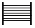
a) Railway track
b) Stone steps
c) Road
d) Ladder
View Answer
Explanation: The above symbol is standard conventional sign for stone steps. This symbol is used to represent the stone steps in topographic map.
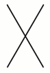
9. Identity the below symbol.
a) Temple
b) Mosque
c) Church
d) Grave
View Answer
Explanation: The above symbol is standard conventional sign for grave. This symbol is used to represent the grave in topographic map.
10. Identity the below symbol.
a) Boundary pillar
b) Boundary pillars
c) Boundary marker
d) Mosque
View Answer
Explanation: The above symbol is standard conventional sign for boundary marker. This symbol is used to represent the boundary marker in topographic map.
Sanfoundry Global Education & Learning Series – Surveying.
To practice all areas of Surveying, here is complete set of 1000+ Multiple Choice Questions and Answers.
If you find a mistake in question / option / answer, kindly take a screenshot and email to [email protected]
- Check Civil Engineering Books
- Apply for Civil Engineering Internship
- Check Surveying Books
- Practice Civil Engineering MCQs
