This set of Spaceflight Mechanics Multiple Choice Questions & Answers (MCQs) focuses on “Coordinate Systems – Azimuth Elevation System – Set 2”.
1. The Azimuth Elevation system uses which two parameters to identify the location of any celestial object?
a) Altitude, Azimuth
b) Azimuth, Declination
c) Right ascension, Declination
d) Altitude, Declination
View Answer
Explanation: To identify the location of any celestial object, the Azimuth Elevation system uses two parameters, Altitude & Azimuth. In the Equatorial Coordinate system, the two parameters used are Right ascension & Declination.
2. Which of the following statements are true about Altitude?
a) It is analogous to longitude
b) It is the angular distance of a point from the horizon
c) It is measured in hours
d) Above the horizon is considered as negative sign
View Answer
Explanation: Altitude is the angular distance of a point from the horizon in vertical direction. So it is analogous to latitude system of the Earth & it is measured in degrees. Above the horizon is considered as positive sign whereas below the horizon is considered as negative sign.
3. Which of the following is the correct representation of Altitude?
a) 0° = Celestial Horizon
b) +90° = Nadir
c) -90° = Zenith
d) 0 hour = Celestial Horizon
View Answer
Explanation: 0° Altitude represents the Celestial Horizon as the vertical distance from the horizon is zero. The angular distance is measured in degrees and not in hours. Above the horizon is considered as positive sign & below the horizon is considered as negative sign. So the Zenith can be represented as +90° whereas the Nadir is represented as -90° altitude.
4. All the objects with same altitude lie along a circle parallel to the horizon, called Almuncantar.
a) True
b) False
View Answer
Explanation: The celestial objects that lie at same vertical distance from the horizon actually lie on a circle parallel to the horizon. This circle is analogous to the latitude system of the Earth, & is known as an Almuncantar.
5. What is true statement regarding Azimuth?
a) It is analogous to latitude
b) It is the angular distance measured from the North point of horizon
c) It is the angular distance measured from the East point of horizon
d) It is measured in hours
View Answer
Explanation: Azimuth is the second parameter of the Azimuth Elevation system & is defined as the angular distance measured from the North point of horizon in the horizontal direction. It is analogous to the longitude system of the Earth & is measured in degrees.
6. The Azimuth value increases from 0° along the horizon, eastwards from the North point.
a) True
b) False
View Answer
Explanation: The North point of the horizon is considered 0° Azimuth. From that point, we measure distance eastwards. The value of Azimuth increases as we go towards east from 0° point. So that 90° Azimuth is the East point of the horizon whereas 180° & 270° represents the South point & the West point respectively.
7. From the given options, which is the incorrect representation of the Azimuth?
a) 0° = North point
b) 90° = East point
c) 180° = West point
d) 270° = West point
View Answer
Explanation: The North point of the horizon is considered 0° Azimuth. From that point, we measure distance eastwards. So that 90° Azimuth is the East point of the horizon whereas 180° & 270° represents the South point & the West point respectively.
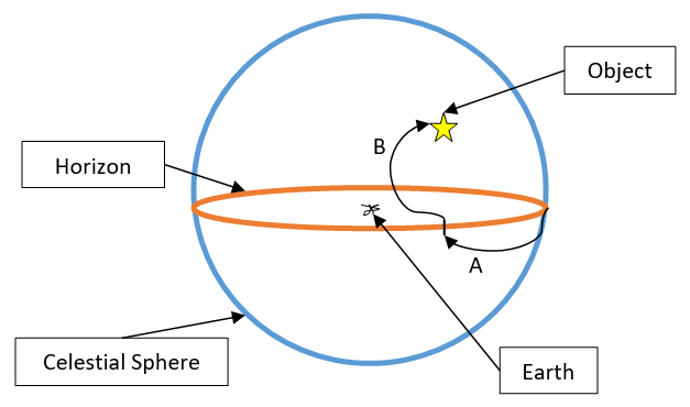
8. Identify the names the parameters labeled as A & B.
a) A = Altitude, B = Azimuth
b) A = Altitude, B = Altitude
c) A = Azimuth, B = Azimuth
d) A = Azimuth, B = Altitude
View Answer
Explanation: Azimuth is defined as the angular distance measured from the North point of horizon in the horizontal direction. As curve ‘A’ measures distance horizontally, it represents the Azimuth value. Altitude is the angular distance of a point from the horizon in vertical direction. As curve ‘B’ measures distance vertically, it represents the Altitude value.
9. Choose the correct location of a star which is at 20° celestial latitude and along a vertical circle passing through East point of the horizon.
a) Altitude = +20° & Azimuth = 90°
b) Altitude = -20° & Azimuth = 90°
c) Altitude = 90° & Azimuth = +20°
d) Altitude = 90° & Azimuth = -20°
View Answer
Explanation: Azimuth is defined as the angular distance measured from the North point of horizon in the horizontal direction. As the star lies on the vertical circle passing through East point, it represents the Azimuth value. East point of horizon has 90° Azimuth. So the Azimuth value of the star is 90°. Altitude is the angular distance of a point from the horizon in vertical direction. As the star is located at 20° celestial latitude, the Altitude is considered as +20°.
Sanfoundry Global Education & Learning Series – Spaceflight Mechanics.
To practice all areas of Spaceflight Mechanics, here is complete set of 1000+ Multiple Choice Questions and Answers.
If you find a mistake in question / option / answer, kindly take a screenshot and email to [email protected]
